North Ohau Hut
Tararua Forest Park
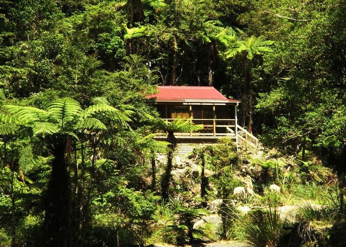
North Ohau Hut is a cozy 4-bunk hut in the middle reaches of the North Ohau River in the Tararuas. A joint project of Horowhenua Deerstalkers and DoC. The best designed of small huts built in recent years: fully insulated, light and including a wood-burner and 4 bunks. The deck is almost as big as the hut, with a view over the river. A great hut and a great sign if this to be the template for future construction. Who says small huts can't have a fire!
Access is not simple, meaning this hut doesn't get a huge amount of use. Most people walk up the Ohau River which includes at least one gorge. The river changes after each flood, but count on getting your shorts wet.
Great work has been done on cutting 'Al's Track' up the ridge behind the hut to pt 897 (starts behind the longdrop). From the ridge a good spur 300m to the north leads to the Mangahau river 2km above Mangahao Flats hut, or the ridgeline south takes you to for Girdlestone Saddle.
|
Owner
|
Owner: DOC |
|---|---|
|
Category
|
Standard Hut |
|
Sleeps
|
Sleeps 4
4
|
|
Facilities
|
Toilet, Enclosed wood/coal burner |
|
Water supply
|
Tap or tank water |
|
Getting there
|
Poads Road (Levin): Here ->Swingbridge 4km (2-4hrs, river route, gorges) ->Poads Road 4km (1-1.5hr, track) Mangahau Road (Shannon): Here ->Mangahau Rvr 2km (track to pt 897, route to river, 1.5-2.5hrs) ->Mangahau Flats Hut 2.5km (45m-1.5hr, track) ->roadend 9km (2.5-6hrs, track) Te Matawai Hut: Hut ->Girdlestone Saddle 3km (track to ridge, route beyond) ->Te Matawai Hut (2.5km, 1.5-2.5hrs) Sth Ohau Hut: 5km (2-4hrs, riverbed route / bush route via Deception Spur) |
|---|---|
|
Unlocked
|
This hut is unlocked and open to access. |
|
Bookings
|
No bookings — open access
No — open access
|
|
Altitude
|
300m |
|---|---|
|
Mobile phone coverage
|
No coverage |
|
Maps
|
NZTopo50-BN33
|