Hillary Trail
Waitakere Ranges Regional Park
- 4 – 6 days one way
- Medium
- Bookings required
- Section 1: Arataki Visitor Centre to Karamatura
12.3km, 4–5 hours
- Section 2: Karamatura Valley to Whatipu
10km, 5-6 hours
- Section 3: Whatipu to Karekare
10.2km, 4-5 hours
- Section 4: Karekare to Piha
11km, 4-5 hours
- Section 5: Piha to Anawhata Farm
4.7km, 1.5-2 hours
- Section 6: Anawhata Farm to Te Henga
12.5km, 5-6 hours
- Section 7: Te Henga to Muriwai Beach
15km, 5-6 hours - Section 8: Swanson Link
18.5km, 7.5-8.5 hours
A spectacular coastal walk in the Waitakere Ranges west of Auckland. ALOT OF THIS TRAIL IS CLOSED FOR KAURI DIE BACK PREVENTION. CHECK DOC TO SEE WHICH SECTIONS ARE STILL OPEN
|
Walking time
|
4 – 6 days
28 hr 30 min – 35 hr
|
|---|---|
|
Distance
|
76.0km |
|
Type
|
One way
|
|
Grade
|
Medium
Long days, rough and muddy tracks. Grades explained
|
|
Bookings
|
Bookings required
Required
Campsites must be booked in advance through Auckland Council.
|
|
Starts
|
Arataki Visitor Centre, 300 Scenic Dr, Oratia, Waitakere 0604 |
|---|---|
|
Ends
|
Motutara Rd, Waitakere, Muriwai 0881 |
|
Maps
|
NZTopo50-BB31
NZTopo50-BA30 NZTopo50-BB30 |
|
Altitude
|
Sea level
–
420m
Altitude change 420m
|
|
Link
|
regionalparks.aucklandcouncil.govt.nz/hillary-trailhttp://regionalparks.aucklandcouncil.govt.nz/hillary-trail |
|---|---|
|
Bookings
|
Bookings
regionalparks.aucklandcouncil.govt.nz/articles/suggested-itineraries-and-booking-informationhttp://regionalparks.aucklandcouncil.govt.nz/articles/suggested-itineraries-and-booking-information |
The Waitakere Ranges were Sir Edmund Hillary's backyard. He prepared for his expeditions walking these hills and beaches. The Hillary Trail was opened in January 2010 to honour his memory, and to provide a challenging multi-day journey close to Auckland City. The trail links together a series of existing tracks through the dramatic landscape.
Days can be long, and tracks can be rough and muddy. The full 76km journey is not a track for beginners, but it can also be tackled as a series of excellent day trips.
Book campsites along the track by contacting Auckland Council Parks on 09 301 0101 or by visiting the Arataki Visitor Centre. The Te Henga Walkway section may be closed for lambing between 1 August and 1 October. Note that this is a long trail with limited camping options and water supply.
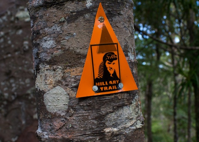
The trail is divided into 7 sections with an additional section providing an alternate exit point. The route is a confusing tangle of track names and junctions, but distinctive orange markers indicate the way.
Section 1: Arataki Visitor Centre to Karamatura
The journey starts at the Arataki Visitor Centre on Scenic Drive. Maps and information are available here, along with weather updates.
Follow Slip Track over an old tramway down to Pipeline Track and then the Lower Nihotupu Dam Road. Follow Hamilton Track, then Smiths Road and Huia Dam Road south through the Huia settlement. At the museum, follow the Karamatura Valley signs.
Section 2: Karamatura Valley to Whatipu
Head upvalley to Karamatura Forks, then left onto the Donald McLean Track. Take the time to visit the summit of Te Rau-o-te-Huia / Mount Donald McLean before dropping down to Whatipu on the Puriri Ridge and Omanawanui Tracks. A short walk near the bottom leads to the old Signalman's house and a view of Paratutae Island.
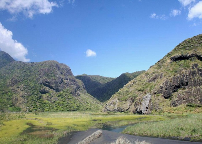
Section 3: Whatipu to Karekare
This section leads northward, high above the Whatipu coastline before dropping out onto the beach at Pararaha. Take the Gibbons and Muir Tracks out to the beautiful Pararaha Valley, where a campsite is located.
The track leads over sand dunes to the Tunnel Campsite.
Through an old railway tunnel, the track leads to Karekare. The next campsite is just along Karekare Road.
Section 4: Karekare to Piha
Comans Track sets off from Watchman Road. Climb along the tops of rugged cliffs, onto the Ahu Ahu and Mercer Bay Loop Tracks. This last track climbs over 200m high sea cliffs onto Log Race Road.
Follow the road out to Piha Road, then turn right and walk up to the Ussher Track. This leads on to the Winstone and Kauri Grove Tracks. Head downhill on the Connect Track then Knutzen Track to the beautiful Kitekite Falls. Head on down to Glenesk Road and Piha Road. Piha Village offers a store, café, public toilets, and campground. The distinctive profile of Lion Rock / Te Piha stands tall on the beach.
Section 5: Piha to Anawhata Farm
Head along the black sand beach to the North Piha Surf Club. Cross the road and follow the Marawhara Walk up the side of Marawhara Stream. This walk leads on to White Track, and a good climb up to Anawhata Road. Turn right and head up to the Kuataika Track, or continue on up the road to a campsite.
Section 6: Anawhata Farm to Te Henga
Kuataika Track crosses Anawhata Stream and passes Kuataika Trig (265m on a short side track) on the way to Wainamu Junction. Houghton Track leads down to Lake Wainamu. Turn right and follow the shoreline to the sand dunes at the outlet. The markers lead to Te Henga (Bethells Beach).
Section 7: Te Henga to Muriwai Beach
Te Henga Walkway is the final section of the Hillary Trail. It starts opposite the Lake Wainamu car park, leading along cliffs to Constable Road. Take the road up to Oaia Road. Follow Oaia Road To the Edwin Mitchelson, Lookout, and Quarry Tracks, dropping into Muriwai. The track ends with a visit to the gannet colony at Otakamiro Point.
Section 8: Swanson Link (alternate exit)
This alternate exit starts at Wainamu Junction (section 6) and finishes at the Swanson Railway Station.
Follow Smyth Ridge Track to Smyth Corner, then right onto Long Road Track and Upper Kauri Track, part of the Montana Heritage Trail. Turn right onto Auckland City Walk, to Anderson Track. Anderson Track leads up to Scenic Drive. Drop steeply down the Peripatus Track to the Swanson Pipeline Track. Turn left and follow it out to the road.
Tram Valley Road becomes Christian Road, then joins Swanson Road. The railway station is just to the right.
Walking times
Alternate exit: