Otukota Hut
Ruahine Forest Park
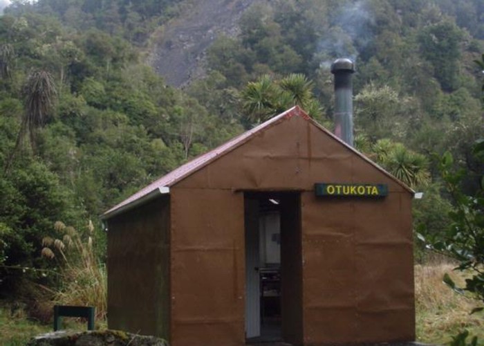
Otukota Hut sits on a small shelf 50m above the Maropea River. It's an older forestry-style hut in tatty condition (06/2009) with the lining chewed out by rats. That said, it is weather-proof, has 6 bunks, a pioneer stove and tank water. There's a view down the Maropea from the helipad, but unfortunately the long-drop door faces the wrong way to appreciate it during your morning contemplation. Dry firewood can be a challenge.
The fork of the Mokai Station track (west) and Bruce Ridge track (south) is 100m above the hut, not at the hut itself. There's a signpost.
|
Owner
|
Owner: DOC |
|---|---|
|
Category
|
Standard Hut |
|
Sleeps
|
Sleeps 6
6
|
|
Facilities
|
Toilet, Enclosed wood/coal burner |
|
Water supply
|
Tap or tank water |
|
Getting there
|
Mokai Station: 10km. Track to bushline, poled route over 1200m Mokai Patea tops Kawatau Roadend: 11km (4-8 hrs) Track up Bruce Ridge (sth of hut), unmarked route over 1400m tops. Good track down from Colenso to Kawatau. Wide featureless tops - compass a must in fog Iron Bark Hut (via river): 4km (2-4 hours). Riverbed route Iron Bark Hut (via track): 7km (note: 1000m climb). Track Maropea Forks Hut: 7.5km (time unknown) track, river crossing below hut |
|---|---|
|
Unlocked
|
This hut is unlocked and open to access. |
|
Bookings
|
No bookings — open access
No — open access
|
|
Altitude
|
620m |
|---|---|
|
Mobile phone coverage
|
No coverage |
|
Maps
|
NZTopo50-BK36
|