Lewis Tops
Lake Sumner Conservation Park, Lewis Pass National Reserve
- 1 – 2 days return by the same track
- Medium
- Car park to Bushline: 1 hour
- Bushline to tarns: 1 to 2 hours
A short climb onto the tops at Lewis Pass, providing panoramic views of the area. With camping on the valley floor nearby, the Lewis Tops are ideal for both day and overnight adventures.
|
Walking time
|
1 – 2 days |
|---|---|
|
Distance
|
8.0km |
|
Type
|
Return by the same track
|
|
Grade
|
Medium
From the bushline, the route is poled and somewhat vague. Travel along the tops themselves is unmarked. Grades explained
|
|
Bookings
|
No bookings — open access
No — open access
|
|
Starts
|
Lewis Pass car park, SH7. Look for the road signs indicating the northern end of the St James Walkway. |
|---|---|
|
Maps
|
NZTopo50-BT23
|
|
Altitude
|
907m
–
1,568m
Altitude change 661m
|
The Lewis Tops offer outstanding panoramas of the surrounding peaks, with the Apprentice and Mount Technical along the ridge, the Libretto, Opera, Spenser, and Freyberg ranges all nearby, and with precipitous views down to the Maruia and Lewis rivers sparkling along the valley floors.
Lewis Pass is a driving route crossing the Southern Alps between Canterbury and the West Coast. Although around the same altitude (900m) as Arthur's Pass to the south, the landscape is not so rugged, and the roadside remains forested.
The pass itself is marked by a pretty tarn and a car park at the beginning of the St James Walkway. From here, the road to Canterbury and the East Coast follows the Lewis River draining to the south. From the northeast, the Maruia River spills out of the the deep, straight Cannibal Gorge, bending westward to meet the road through to the West Coast. Unlike the dramatic Arthur's Pass road, there's little to see from a car and the pass itself is not obvious. The best way to see Lewis Pass is to get out and walk!
Access
The track once started at a sketchy car park on the bend at the road's highest point. But it has since been rerouted to the main car park, which is more convenient, safer, and easier on vehicles. There are several short walks at the car park, plus a shelter, water supply, toilet, and sandflies.
Car park to bushline
From the car park, walk 150m up the road. The track is marked by a small sight on the opposite side of the road, near where the trees return. The track follows the road through forest to the bend in the road nearby, before turning uphill to climb a spur at the end of the tops.
Beyond here, a vague, rocky scramble soon enters pretty beech "goblin forest." A fairly rough, slippery, marked track climbs directly up the hillside, gaining height quickly. Nearly 400m above the road, the track bursts suddenly out onto tops, and a poled route continues directly uphill.
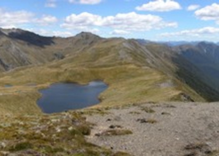
Take a few minutes to look at the view from here. North is the east-west Maruia Valley, with Mt Freyberg and the Left Branch of the Maruia across the valley. Northeast is the long Cannibal Gorge and, above it, the Spenser Mountains: the notched peak of Gloriana, with Faerie Queene (2236m) to the right. Next along and nearer is the brown tussock top of Zampa, also part of the Spensers. Directly across the valley to the east is Trovatore (1737m), with a marker visible on the peak at the summit of a long, gentle tussock arm. Travers Peak is the dome in behind. The Libretto Range follows the Lewis Valley off to the south. Down on the valley floor, vehicles are visible moving along the highway, as is the dark tarn at the St James car park.
Bushline to tarns
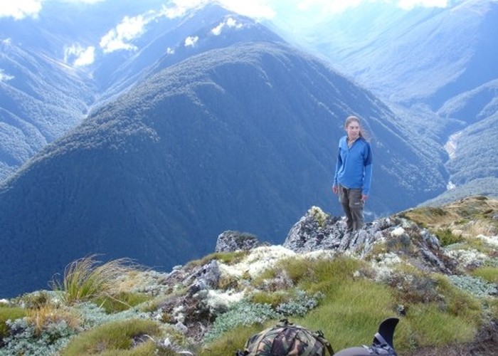
From the bushline, a vague track follows the spur, climbing another 280m to the summit (1568m) at the eastern end of the tops. A vertiginous drop develops to the right, with views of the valley floor almost a kilometre down. From the summit, Deer Valley to the left and the impressive northern slopes of Mt Technical (1870m, topped by twin masts) beyond it become visible.
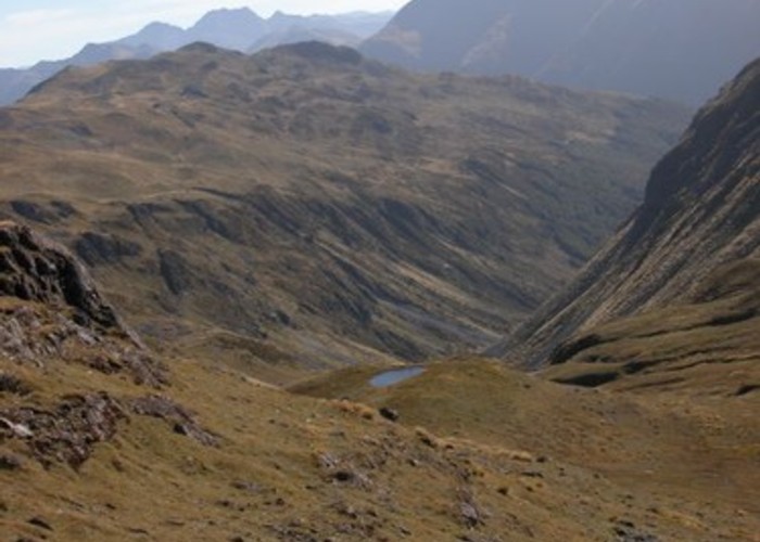
The Lewis Tops is a rolling ridge extending to the west as far as Waterfall Creek above Maruia Springs. The tops are near the western edge of the Triassic greywackes that form the eastern Southern Alps. To the west, the rocks are schist, metamorphosed along the Alpine Fault. Here, the strata rise vertically, forming the rolling east-west ridge, and trapping small tarns in the pockets between the harder layers. Little ridges like moraines or railway embankments are obvious on the southern edge of the tops, running lengthwise. Easiest, although exposed, walking is on the northern edge. The route from here is unmarked.
The first of the tarns is nearby, and there is lots of camping space here. The views of Mt Technical and Deer Valley improve further along. From the western end of the tops, views extend along the northwest curve of the Maruia River to the farmland flats of Springs Junction.