Inland Pack Track
Paparoa National Park
- 2 – 3 days one way
- Easy
A beautiful historic route through a coastal karst environment. Gorges, caves, waterfalls, subterranean rivers, sink-holes, swimming, and camping beneath a giant overhang.
|
Walking time
|
2 – 3 days
9 hr 30 min – 10 hr 30 min
|
|---|---|
|
Distance
|
31.0km |
|
Type
|
One way
|
|
Grade
|
Easy |
|
Bookings
|
No bookings — open access
No — open access
|
|
Starts
|
Punakaiki River, SH6, 2km south of Punakaiki |
|---|---|
|
Ends
|
Fox River, SH6, north of Punakaiki |
|
Maps
|
NZTopo50-BS19
NZTopo50-BS20 |
|
Altitude
|
Sea level
–
200m
Altitude change 200m
|
The climate is warm and coastal and the eroded limestone landscape includes gorges, caves, forest streams, disappearing rivers and waterfalls that begin at ground level. The track dates from the 1860s; it was cut as an alternative to travel along the rugged Punakaiki coastline and remained in use for 40 years. Of course there's a highway now so the track can be walked as a loop beginning at Punakaiki. Vehicle traffic can make the 12km walk along the road unpleasant but public transport is also available. DOC recommends that you walk the Inland Pack Track beginning at the Punakaiki River end as there is a danger of missing some track turn-offs if you depart from Tiromoana. However, the reverse journey seems preferable and will be described here. Travel up to the Ballroom, along Dilemma Creek or the crossing of Bullock Creek would be impossible when rivers are in flood.
A range of native orchids may be seen along the track. Thelymitra and Microtis can be seen growing in the grassy banks along the road; Pterostylis grow alongside the lower parts of the track near Tiromoana; Corybas may be found growing in secret colonies in the bush of the gorges;Winika cunninghamii and Earina autumnalis perch in the trees south of Bullock Creek.
Access
Twelve kilometres north of Punakaiki along State Highway 6 you cross the Fox River bridge. Over the bridge a sign points up-valley to the tourist caves; follow the vehicle track. The clear, flat space here is the site of the gold town, Brighton. Bill Fox struck gold here in 1866 and there were at one point 5000 people living here. The town disappeared in less than a decade. There is comfortable camping in the area, a picnic table by the beach, driftwood, and flounder in the river mouth for fishwatchers.
Fox River Mouth to Dilemma Creek Confluence: 2.5 – 3 hr
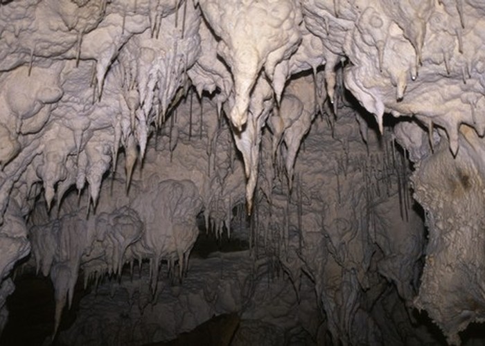
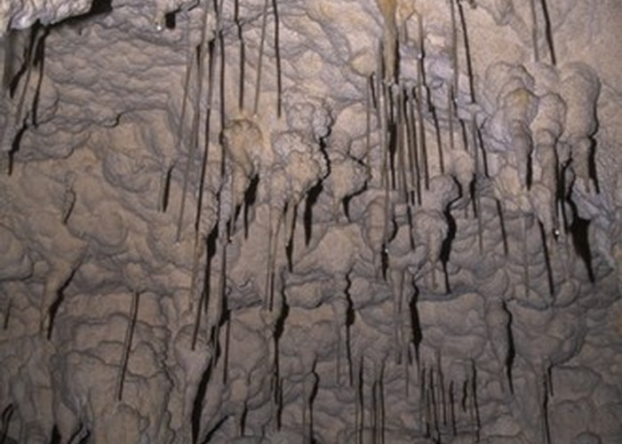
Follow the north bank of the river on the trail to the Fox River Caves. You will reach a junction where a sign indicates the Inland Pack Track across the river, while the trail continues to the caves. You may want to leave your packs here while you visit the caves and return for them later. Eventually you will come upon a small arrow pointing leftward where the track bends directly uphill. If you haven't dropped your pack yet, drop it here. It is a short, rocky clamber up to the caves, avoiding the ongaonga (native tree nettle). You will come to a large cavern in the hillside from whence several passageways begin. The cave in the upper left corner is safe to enter and explore. Cave wetas may be found in here. The main cave to the lower right connects to 2km of passageways, but there are dangerous rifts in the floor near the entrance and it should be avoided.
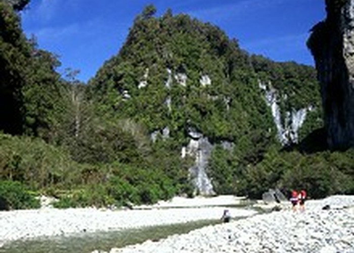
On departing the caves you have two options. The simplest is to return to the junction and cross the river, following the trail along the south bank until you come out at the confluence of the Fox River and Dilemma Creek. The second option is to follow an old, overgrown track that begins where the caves access track turns directly uphill. From here the barely visible track runs directly downhill. It is steep and slippery, overgrown with supplejack, and blocked by fallen trees. Under the rock pile to the left of the trail you will begin to hear the rushing of what apparently is the resurgence of Cave Creek North. On the river-bed continue upstream to the junction of the gorges. You can truly appreciate the limestone landscape from here, and if the weather is warm the occasional deep fords make for excellent swimming. Occasionally against the brilliant white of the granite river-stones you will find a rounded, black coal pebble.
Side trip: Dilemma Creek Confluence to The Ballroom: 30 min
From the Dilemma-Fox junction continue upriver to the Ballroom. This is a very large overhang carved out by the river, with an expanse of flat ground underneath. You can camp here or try the forest on the far bank a little upriver.
Dilemma Creek Confluence to Bullock Creek: 4 hr
From the confluence follow Dilemma Creek along a narrow gorge until it opens out onto flat land. Where the creek-bed bends leftward you will see a small waterway emerging from the bush on the right (true left) bank. A sign should be nearby. This is Fossil Creek, and easily missed. Further upstream, Dilemma Creek spreads out onto shingle flats, where camping is possible. Further still, the banks close in and the river runs deeply between them. Follow Fossil Creek for approximately 30 minutes, watching for the beginning of the pack track proper on the right (true left) bank. It should be indicated by a sign and cairn. Some distance along this track you will hear the thunder of falling water to your right shortly before you cross a larger stream. If you head off the track, towards the sound, you can watch as the stream plunges over a waterfall and disappears underground (not to be missed!). The track in this area is edged with tiny, white forest irises.
Over a ridge, you sidle by the Bullock Creek farmland until the track moves out of the bush and follows a vehicle track to a ford of Bullock Creek. This farmland is not a part of the national park; it is, however, owned by DOC. You can camp here, at the point where Bullock Creek disappears underground, but be wary of camping too close to the river-bed.
Bullock Creek to Punakaiki River: 3.5 – 4 hr
Follow the vehicle tracks and signs up a low hill. The track soon re-enters mature forest; keep to the track as there are deep potholes alongside its course. The sound of a waterfall at one point issues from Cataract Pot, where another river disappears underground. After a track junction, you will come to the delightful Pororari River. Ford it and continue through to the delightless Punakaiki River. Uninspiring camping here. After crossing the river, follow the vehicle track through the grass and scrub to the picnic area at the highway. It's an easy walk north to Punakaiki from here.