Readon Hut / Reardon Hut
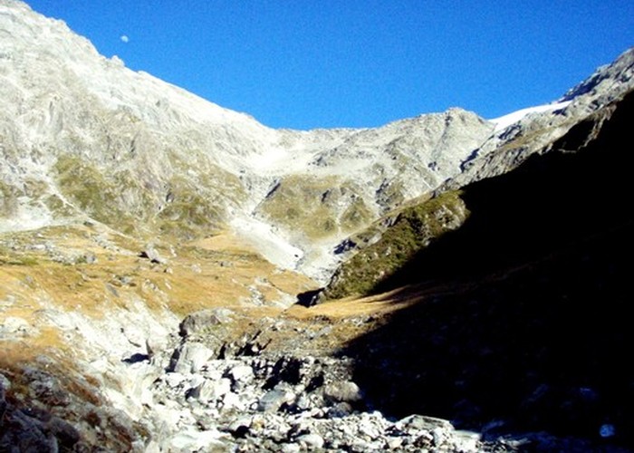
Rea(r)don Hut (2 bunks, matresses, tank water, no fire) is a large bivvy / small hut near the head of the Dobson. Signposts and maps differ on the spelling of the name, both Readon and Reardon being used. The hut lies on the last of the river flats before the valley gorges out as it enters the ice-capped Sealy Range. Glaciers descend from Mt Hopkins opposite the hut, and the endless cacking and crashing of ice falling from their snouts to the valley floor may accompany (or prevent) your slumber.
Most users of the hut are hunters after red deer on the lower valleysides. That said, the location is worth a visit for the glacier views alone. Additionally, for the adventurous, several intersting alpine routes exist from/to the hut:
- Jamieson Saddle from Brich Hill Stream: unmarked alpine route, rock/scree in late summer
-Burton Saddle from Mueller Hut / Glacier: alpine, snow/ice/glacier travel
- Tragedy Col from the Hopkins: alpine route snow/ice
|
Owner
|
Owner: DOC |
|---|---|
|
Category
|
Basic Hut/Bivvy |
|
Sleeps
|
Sleeps 2
2
|
|
Facilities
|
None |
|
Water supply
|
Tap or tank water |
|
Getting there
|
Glen Lyon Stn.: 4WD river flats route. Hut -> Waterfall Hut (4km,1-2hrs) -> Kennedy Hut (5.5km,1.5-3hrs) -> Grough Hut (6.5km,1.5-3hrs) -> Le Crens Hut (10km,2.5-5hrs) -> roadend (7.5km) My Cook Village via Jamieson Saddle: unmarked 2187m alpine route over rock/scree. Birch Hill Bridge (SH80) -> Jamieson Saddle (5.5km, 4-8hrs, 1500m climb, scree) -> Readon Hut (8km, 4-8hrs, scree / riverbed route). Permission required: Glentanner Stn. Mt Cook Village is 8km north of Birch Hill by road |
|---|---|
|
Unlocked
|
This hut is unlocked and open to access. |
|
Bookings
|
No bookings — open access
No — open access
|
|
Altitude
|
900m |
|---|---|
|
Mobile phone coverage
|
No coverage |
|
Maps
|
NZTopo50-BY15
|