Ben Lomond
- 5 hr – 6 hr return via same track
- Medium
A peak behind Queenstown, commanding stunning panoramic views.
|
Walking time
|
1 day
5 hr – 6 hr
|
|---|---|
|
Distance
|
11.0km |
|
Type
|
Return via same track
|
|
Grade
|
Medium |
|
Bookings
|
No bookings — open access
No — open access
|
|
Starts
|
Power House Road, along Lake Esplanade, west of city centre |
|---|---|
|
Maps
|
NZTopo50-CC11
|
|
Altitude
|
320m
–
1,748m
Altitude change 1,428m
|
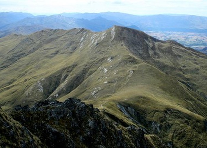
Ben Lomond is a popular day trip from Queenstown and is well worth doing if you have a spare day there. The track is popular, with a small crowd assembling on the summit about middady every day. Nevertheless, this is an alpine environment, so care should be taken. Sturdy footwear, water, and warm and waterproof clothing are required.
Access
From Queenstown, follow the road around the lake toward Glenorchy to a roundabout (walking time from Queenstown, about 15 minutes). Turn up Power House Road to the car park.
(Note The Ben Lomond Track is also accessible from the top of the gondola or from Thompson Street in Queenstown.)
The One Mile Power House was Queenstown's first source of electrical power, constructed after the town's gas plant exploded in 1923. The track climbs steps behind the power house and crosses a wider suburban walking track. The old pipeline leads to an impressive concrete dam after about 30 minutes.
From here, the Ben Lomond Track continues through pine forest, meeting a road at the Midway Clearing on the gondola access road. Head left, up the road for a few metres to the point where the Ben Lomond Track takes up again in pine forest. The Fernhill Loop Track also commences here.
Eventually, the track breaks out onto scrub and tussock (1 hour from car park), with views of Ben Lomond to the left. A junction with the route from the top of the gondola is passed, and the track eases up the spur to the saddle beneath Ben Lomond (2 hr 15 min from car park).
From the saddle, a route leads down to the Moonlight Track and out to Arthur's Point (5 hours), an unmarked route leads up Bowen Peak to the right (about 1.5 hours return), and the Ben Lomond Track leads left, up a steepening spur.
The track climbs quickly, then zig zags, then bends right around the back of the peak before spiralling to the summit (45 minutes from the saddle). From the summit, The Remarkables and Frankton arm are visible to the southeast, Lake Wakatipu and Walter and Cecil Peaks are only slightly higher to the south, and Moke Lake and Moke Creek are visible to the northwest.