
Mt Stevenson was on our ‘to do’ list and through the tenure review process. DoC was able to negotiate an easement to the slopes of Mt Stevenson through the freeholded station from near the Jollie River. Another easement goes along the western edge of the military firing range that extends a long way north to the foot of the mountain. That land formerly belonged to Braemar Station but when they went through tenure review that land went to the Army
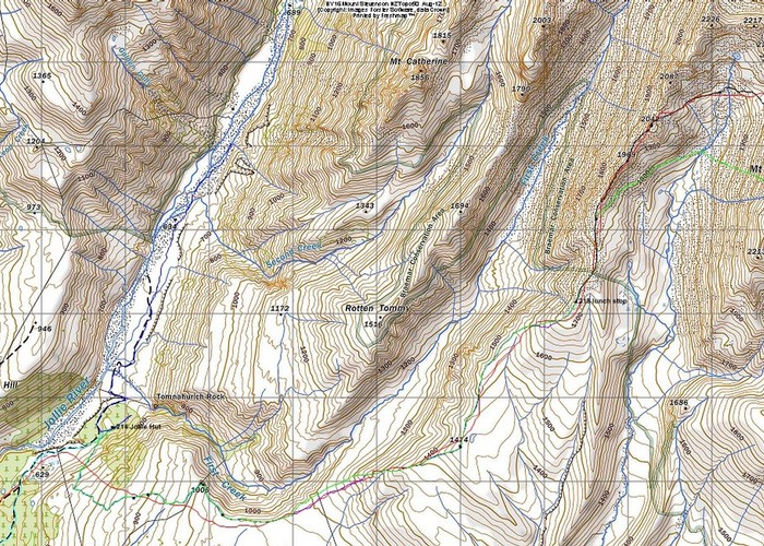
We chose to stay at Jollie Hut which is less than an hour’s walk through both cultivated and wilding forest from the car park on the Braemar- Mt Cook Station Rd. It is a charming old 2 roomed former shepherd’s home by the look of it with 4 bunks, surrounded by stands of ripening currant, raspberry and gooseberry bushes. At some time it has been sheathed in corrugated iron and the chimney has been rehabilitated since then. Unfortunately someone has stove the flue in at the base, forming a gap between the flue and the surrounding concrete collar. It now leaks rain directly into the fireplace and smokes like a bastard. No shortage of firewood though with extensive pine harvesting and massive piles of timber detritus nearby.
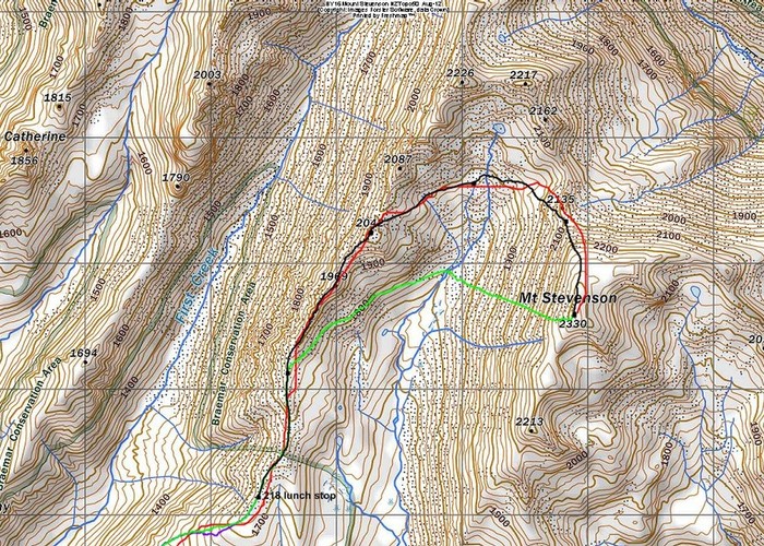
There are various long gentle spurs leading up to the summit massif but we chose the one most west arising from the true left bank of First Creek (no poet run holders, it seems). From near the head of it, we would only need to lose 138 m in height to sidle the basin slopes and climb on talus to the ridge north of our summit. But how to climb through the first 350 vertical metres of girdling conifer forest that had spread on and on to the edge of the plateau? We arrived at the hut in the early afternoon and set off to find out after a drink and settling in.
We discussed the strategy: do we go down to First Creek and travel up it to reach the plateau or try to shove our way through the forest? It looked relatively open and it was densely planted but unmaintained so low branches would obscure our passage. Our hope was to find a forestry road through the forest so we cast about. I could see a bit of a benched track winding upwards. Frank thought it was worthwhile checking what used to be a former gap in the forest but this had completely filled in with wildings and what wasn’t instead was full of dense head-high broom and other nasty weeds. So it was off to explore the forest track.
We soon realized it had been kept open by some motivated person with a chainsaw. We followed up its twistings and turnings. It became more obscure but the unmistakable stigmata of vehicles crushing tussocks lead us on the right path. Pines had been felled and turned orange, also highlighting the correct option when there seemed to be a choice of route. At one point the presence of a lone waratah and a recently felled pine signaled us onwards. After nearly an hour, we broke out into the open grassy pasturelands and tussock at the edge of a terrace high above the true left bank of First Creek. It looked pretty down there but with a lot of no doubt prickly scrub bordering its banks and a bouldered bed it wouldn’t be a good route.
We savored the view: Cook’s south face, Nun’s Veil climbed a decade ago with recent avalanche activity on the face we’d gone up. Mt Sefton with those threatening ice cliffs perched ready to topple over the rocky bluffs they were stacked above. Closer to hand, I was charmed by a violently pink wildflower growing on higher bits of ground - a bit like a very primitive carnation but without the lovely clove smell (seems to be dianthus deltoides).
After a prolonged loaf in the balmy evening, we turned down the hill, making note of junctions and unlikely twists and turns in the tall tussocks fringed by young wilding pines. The next day would be a long one with an 1800 m climb and 14 km of travel to achieve this. The orange sunset spreading golden light around the hut bode well for tomorrow’s weather. We felt happier having sorted out what we hoped was our navigational crux.
The next morning we had a visitor: a hunter who biked in and stopped for a chat as he was locking up his bike to the verandah post. When he read the hut book and saw our day’s objective was to be ‘Stevenson’ he decided to write that as his objective too. This would make him only the second person in the hut book to be expressing intent to climb the mountain. He assured us he would only shoot uphill but I wasn’t too worried as if he was going there via First Creek, he wouldn’t be too far ahead of us by the time we were in the open, taking in to account the unpleasant terrain and the stalking or whatever it is that hunters do. There were a few other peculiarities about thim that had us independently scratching our heads. But then again, he may have been scratching his head over us for all we knew.
We set off an hour later, reached our previous evening’s vantage point in good time and surveyed the scene. The lower flanks of our mountain and all around to the same dew point were sheathed in cloud but we were hoping this would burn off and reveal the surrounding summits. A helicopter was fluffing around below the cloud layer looking for animals to shoot, I suppose. We resumed our climb. Fortunately there were old wheel ruts where a quad bike had passed through so we followed these. I persisted in this direction of travel which took me to a wire fence with a gap. The forest had marched on in the form of little saplings yet to set seed but someone(s) had felled the bigger ones at some stage.
Now it was time for some more earnest height gain. Frank was going faster than I was and I didn’t bother to keep up as it was going to be a long day. He waited for me at the top of a rise which I’d been sidling in my lazy fashion and informed me the first leg had taken us 55 minutes but the second lot of equal height gain had taken him only 50 minutes so he was pleased with his stamina. We travelled along with me in front setting a steady pace until lunch 3 hours after we’d left the hut. We found a north facing rock sheltered from the slight wind which we leaned against. I had a calorie-dense mix of mayo and dried bonito flakes – lots of oil and protein, spread on wraps, to keep me going.
As he was travelling quicker with only a day pack instead of his usual overstuffed burden I ventured on ahead while he lingered in the sun a bit linger. However our gentle spur then developed some pointy bits. I considered it might be a better idea to drop down a bit and take a lead of an old terrace into the lower part of our basin, then climb to the ridge formed by the long summit of Stevenson but thought I’d better stick with the original plan. However I didn’t like the look of the stacked choss and decided to traverse it if I could because I couldn’t guarantee it would be able to be negotiated on the far sides of drop-offs which weren’t in view. Besides the speed of travel was slowing down and we still had a way to go.
So I dropped off on the eastern side and traversed talus-like stuff and low bluffs under the potentially intimidating outcrops. When the ridge looked as though it had smoothed off a bit, I gradually regained the ridge via a pleasant consolidated bit of scree to a slight saddle. From here I tried to spot Frank. He could have done what I did, or persisted on the ridge. It was soon apparent he’d done the latter as I could see him on a small hump so began to cooee until my voice began to fail and I remembered my whistle.
He heard this and whistled back but I didn’t know if he could tell I was ahead of him along the ridge, pussyfooting in some sidle or lying injured somewhere, heaven forbid. I climbed higher still whistling and waving my arms. I was wearing cream and carrying a grey and orange pack so was not that visible. I sidled out to a little saddle off the ridgeline where I’d be more visible; being on the skyline and here he was able to spot me as he now was waving his arms. I waited but realized he was sticking to the ridgeline so sidled over to intersect with him and sat down to wait a little uphill from another slight dip in the ridgeline.
However he stopped just below the rise and began to take his boot off. It was time to communicate so I climbed back up to where he’d stopped to put a plaster on a blister, hoping he wasn’t going to announce the climb was off due to time having been wasted with this escapade of stopping and trying to spot/communicate with each other. I was going to carry on regardless as it all looked good if we now left the ridge to sidle the basin, gradually gaining height to gain the other summit ridge. Luckily we were of one mind and both liked the route of reddish large consolidated talus that would take us to the final section of summit ridge.
He’d decided to carry on along the ridge as he could see I’d chosen not to leave it to travel via the lower terraces. He knew it would be slower going. In hindsight, I should have stopped when I saw the ridge become chossy but I’d been keen to keep that lead as he had the inclination to travel more quickly. I followed him down into the basin as we gradually dropped height to get to the best terrain for our subtle sidle. Time was ticking on though and I managed to keep a bit more in front as his pace was slowing up in the field of talus where careful foot placements were obligatory to avoid any back sliding.
Don’t get me wrong, it’s by no means a race but a pair needs to have a good understanding of where the other one is placed for stamina as the day wears on and some is needed to be kept up our sleeves for the return journey. I reached an aerial which was derelict and non-functioning with the solar panel removed. Ladybirds were clustered on the empty wooden casing. We’ve seen them at other summits, Manakau for example. I continued to what seemed to be the highest cluster of rocks which conveniently looked good for sitting on. Nearby was a small cairn. I guess they’d wanted to leave these nice rocks free for sitting on. Frank joined me and I had a second lunch of feta and wrap, trying to avoid eating ladybirds as they were all over the place.
What a great place and great visibility: Cook, Nun’s Veil again, the tip of Tasman, maybe Sibbald in the distance, Sefton, Sealey and further afield more top of the topo’s – Fox Peak, Kohurau, Mt Dalgety and was that Old Man further south?
A helicopter flew close and then flew back and to my surprise landed only 300 m away on a flat outlying shoulder of the mountain. 6 what we supposed were tourists got out and admired the same view as us, then lined up for their photo to be taken by the pilot in various directions, who was trotting around in shorts. After a while they piled back in and took off so we gave them a wave as they flew overhead.
On the way up, I had been entertaining yet unvoiced thoughts of running down the scree below the summit back to Landslip Creek to enjoy a drink and top up the containers. I wouldn’t have been keen to stumble down the talus the way we came up. Frank mooted our doing a 500 m scree run and I was all for it. I offered him my snow gaiters as I was wearing sock gaiters but he said they were too good to get damaged in the scree. We picked out possible routes out of Landslip Creek, offering the least height gain to join the ridge above where it bifurcated and decided on a more upvalley option.
We put our gloves on and took off and I eventually noticed that it looked as though someone else, surely not an animal had bounded down the way we were going so I followed in their softened footsteps. It was a reasonable scree run and despite wearing nothing in the way of gaiters, no stones entered Frank’s boots.
We reached the pretty stream garlanded by various white flowers then sidled gradually as planned, only having to cross one narrow scree which I went directly across to minimize exertion. We only had to go 130 m uphill in total and I took it at a nice gentle angle as it had been a long day so far. When we met the spur, we had yet another stop and look around then travelled down the spur to the lookout point above the forest where Frank called another halt for a drink. I had a snack of one of his dry old stale muesli bars I’d discovered in his food stores. It was only another 40 minutes or so back to the hut.
We were both pretty tired and felt sunburnt but I had enough energy to make a couple of weird courses for dinner. Those dried anchovies are very salty and don’t try adding hot liquid to custard powder which hasn’t been mixed to a slurry with water. Doh! Never mind. It all went down, bones and salt and lumps and all. I successfully camoflaged the lumps with dissolved gingernuts. The hunter had written in the hut book that he’d been to the summit of Stevenson but we had been examining the mountain all the way there and had seen no trace. As he had no map and even hadn’t known the name of the creek he’d been planning to hunt in, had he climbed Rotten Tommy instead? He also said he’d shot a tahr.
The next day we had the hair of the dog, taking a stroll up the Jollie River. It would have been a shame not to set the scene. The plan was to go as far as Green Point Hut, a couple of hours’ walk up. The valley was full of exotic flowers, more of those pinks and other little plants, monkey musk and the like. We even saw a white flowered viper’s bugloss. Googling it implied it wasn’t all that common but no doubt I’ll see them all over the place now that I’ve noticed they exist. Of course our night pollinating moths might favour them but maybe only the long tongued bumble bees imported for red clover pollination can do the trick. At the point where we needed to cross to inspect the old hut site near Golden Gully we called it a day as the river was up and we weren’t sufficiently motivated to put ourselves at some risk. The gully was no longer golden as the pines had crept up the valley to this point from the forestry block by Jollie Hut.
We had lunch in a nice spot leaning up against the grassy bank by a little yazoo stream running parallel with the main river. On the way back we explored a terrace as a change from the river bank travel then followed the 4WD track back to First Creek, crossed this and retraced our steps up the hill to Jollie Hut. The Norwester was building up in the mountains but it was a perfect overcast day where we were. As we were enjoying afternoon tea before packing up, 2 young and friendly German tourists popped in to find out where a worthwhile walk of around 2 km was. I suggested a walk down to the river to admire the wildflowers.
As an aside, have you noticed when people unfamiliar with the DoC Hut system come, they almost feel as though they have intruded on your home? I’ve even known them to decide to walk right past once they discover the hut is occupied. But when encouraged to come in, they’ve been friendly enough.
We packed up and left the already clean and tidy hut even tidier. I burnt some paper rubbish, old discarded toilet paper and rolls and old tea light wax in the fireplace. We walked out through the cutover or unmaintained forests, noticing shabby neglected buildings as the farm wasn’t relying on pastoral activities much to make its money. There were even Highland cattle and American bison there. Perhaps they were for trophy shooting as this is run as a business by Mt Cook Station. I guess tenure review had paid for the extensive but unoccupied deer fenced paddocks bordering the road.
We drove back via the metalled Braemar Road which Te Araroa folks use to trudge along between Tekapo and Pukaki. Here there are plenty of kettle lakes, the easement into Landslip Creek and the Telephone Hut, a 2 bunk, 1 mattressed windowless wee hut on crown land by the road used by the long pathway travelers. Windy in the NW wind according to the comments on the walls but it has a fire place and someone has supplied wood. We drove on, eschewing the touristic delights of Tekapo and slummed it at a takeaway with tables where we had a meal no better than it should be for the price of $16 each and indeed a lot worse to my way of thinking. The service was however superb and the apologies for the intially very rare i.e. mostly raw (and weird tasting) ‘steak’ were profuse. I’d forgotten that chips can be served saturated in cooking oil as it’s been a while but this is a trip report, not a restaurant review so I’ll end it there.